


Appmenazas
Description of Appmenazas
Aprende más sobre las amenazas naturales con las que convives a diario en las principales ciudades de Venezuela.
Con el uso de mapas interactivos, fotografías, vídeos y documentos científicos podrás conocer de una manera fácil y educativa las amenazas naturales (terremoto, tsunami, inundaciones, entre otras) que pueden afectar a tu ciudad.
Con Appmenazas los habitantes de las ciudades venezolanas se sensibilizan y empoderan sobre las dinámicas territoriales con las que cohabitan y de esta manera pueden reducir los niveles de riesgo a los que están expuestos, gracias a la lista de recomendaciones para cada amenaza, diseñadas por científicos venezolanos especialistas en el área.
¿Por qué Appmenazas?
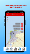
■ Describe 5 tipos de amenazas naturales: terremoto, tsunami, inundaciones, movimientos en masa y aludes torrenciales.
■ Fácil de usar e interactiva.
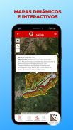
■ Los mapas cuentan con diferentes niveles de zoom y la información puede ser consultada al tocarlos.
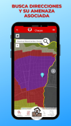
■ Busca direcciones como tú hogar o lugar de trabajo.
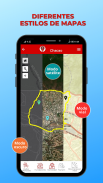
■ Diferentes estilos de bases cartográficas: vial, satélite y oscuro.
■ Con la opción de GPS puedes conocer si te encuentras actualmente en una zona expuesta a amenazas naturales.
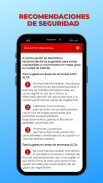
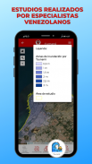
■ Consulta las recomendaciones para cada amenaza natural elaboradas por especialistas.
■ ¿Quieres saber más sobre las amenazas naturales? Puedes descargar las fuentes científicas utilizadas.
■ La información es complementada con fotografías, vídeos y links a páginas web de interés.
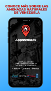
Esta primera versión aborda diagnósticos y recomendaciones aplicables a las ciudades de Cumaná, Mérida y el municipio Chacao, de la Gran Caracas.
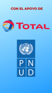
Desarrollado por la Alianza CIGIR-LSIGMA (USB), con el apoyo de Total Oil and Gas de Venezuela y el Programa de Naciones Unidas para el Desarrollo (PNUD).
Learn more about the natural hazards that you live with on a daily basis in the main cities of Venezuela.
With the use of interactive maps, photographs, videos and scientific documents, you will be able to learn in an easy and educational way the natural threats (earthquake, tsunami, floods, among others) that can affect your city.
With Appmenazas, the inhabitants of Venezuelan cities are sensitized and empowered about the territorial dynamics with which they coexist and in this way can reduce the risk levels to which they are exposed, thanks to the list of recommendations for each threat, designed by Venezuelan scientists specialists in the area.
Why App Threats?
■ Describe 5 types of natural hazards: earthquake, tsunami, floods, mass movements, and torrential landslides.
■ Easy to use and interactive.
■ The maps have different zoom levels and the information can be consulted by touching them.
■ Look up addresses like your home or place of work.
■ Different styles of cartographic bases: road, satellite and dark.
■ With the GPS option you can find out if you are currently in an area exposed to natural hazards.
■ Consult the recommendations for each natural hazard prepared by specialists.
■ Do you want to know more about natural hazards? You can download the scientific sources used.
■ The information is complemented with photographs, videos and links to web pages of interest.
This first version addresses diagnoses and recommendations applicable to the cities of Cumaná, Mérida and the Chacao municipality, of Greater Caracas.
Developed by the CIGIR-LSIGMA Alliance (USB), with the support of Total Oil and Gas de Venezuela and the United Nations Development Program (UNDP).
Appmenazas - Version 1.0.0
(07-09-2020)Appmenazas - APK Information
APK Version: 1.0.0Package: ve.org.cigir.appmenazas


 4.83
4.83


Apps in the same category


